GIS Based Approach for Analysis of Habitat Suitability and wildlife conservation for African Buffaloes (Syncerus caffer) at Dhati Welel National Park, Ethiopia
Abstract
Wildlife management is a crucial issue to maintain the sustainability of an ecosystem whereas habitat suitability analysis is very important for better conservation and management of species like the African Buffalo. Therefore, the effort of this study was to analyze habitat suitability for African Buffalo (Syncerus caffer) by employing GIS at Dhati Welel National Park, Ethiopia. The study employed five datasets include: land use land cover (LULC), elevation, slope, settlements, and rivers. In this study, the Analytic Hierarchy Process (AHP) and weight overlay analysis methods were applied using IDRISI 17 and ArcGIS 10.5 software. Each dataset was integrated using GIS and AHP to rate the individual classes of each factor and weigh the influence of one factor against the other, to determine the weighted contribution of importance to the habitat suitability. As result, the consistency ratio was 0.03 and found with acceptable limits. Then, the weighted overlay tool was applied to calculate the final habitat suitability map of the African Buffalo based on the influence value. The result indicates, 35.3 % (362.7 km2) of the study area was optimal for the African Buffalo habitat. Therefore, according to the results of the finding more areas of Dhati Welel National Park are suitable for the African Buffalo habitat based on the factors employed in this study. So that, this indicates the area is important for conservation from habitat loss and fragmentation.
Article Information
- Received
- Accepted
- Published
Academic Editor: Andreia Manuela Garcês, University of Trás-os-Montes and Alto Douro.
Checked for plagiarism: Yes
Review by: Single-blind
Copyright © 2023 Tekalign Ketema Bahiru
 This is an open-access article distributed under the terms of the Creative Commons Attribution License, which permits unrestricted use, distribution, and reproduction in any medium, provided the original author and source are credited.
Corresponding author: Tekalign Ketema Bahiru, Department of Geographic Information Science, Oda Bultum University, Chiro, Ethiopia —
Competing Interests
The authors have declared that no competing interests exist.
Funding
This research received no external funding.
Data Availability
The authors will provide the data used for habitat suitability analysis of African Buffaloes that supported the results presented in the paper. Additionally, data that support the findings and maps that have resulted from this study will be made available on request from the corresponding author.
Citation:
Introduction
Wildlife management is an issue of global importance where habitat suitability mapping is essential for better management and conservation 31, 32, 33. It is not only the preservation of wildlife species, but it also involves the management of a complete ecosystem 18, 29. Moreover, it attempts to balance the needs of wildlife with the needs of people using the best available science. Wildlife management includes gamekeeping, wildlife conservation, and pest control 16.
Habitat loss, fragmentation, and degradation pose direct threats to wildlife species worldwide that are driven by human population growth, unsustainable consumption of natural resources, and policies that do not fully value biodiversity 4, 5. Habitat destruction is widely accepted as the leading cause of wildlife extinction rates in recent decades 23. Furthermore, fragmentation and habitat loss, due to anthropogenic pressures are one of the major challenges to conservation 3 and are considered a major threat to the viability and status of populations, species, and ecosystems around the world 30, 11.
Habitat destruction and fragmentation are the most critical threats to biodiversity and ecosystems throughout the world 6. It affects the survival of wildlife populations by reducing the number of available habitats, reducing habitat quality, and creating edge effects 13. Habitat loss has pervasive and disruptive impacts on biodiversity and its magnitude of ecological impacts can be exacerbated by habitat fragmentation 14, 2.
In Ethiopia, The expansion of agricultural practices, settlement in and around the Sanctuary, and increasing pressure from human and livestock populations are major threats to several protected areas 21. Moreover, the Lack of proper management is a problem that is threatening the quality and quantity of wild biodiversity in Ethiopia 13.
In Dhati Welel National Park, habitat loss and fragmentation is rapid and pose a severe threat to the survival of most wildlife species 19. It has been under increasing pressure from the rapidly growing human population agricultural land expansion, and the increment of livestock number 19. Encroachment from the surrounding communities is currently among the major problems the park is facing.
The African buffalo is a large sub-Saharan African bovine that is found throughout most of sub-Sahara Africa including Ethiopia. Presently their distribution is considerably reduced and in many areas largely limited to reserves. Their habitat is fragmented in many areas by human activity and their numbers have been hugely reduced 1.
The Dhati Welel National Park contains Syncerus caffer caffer species. According to Dhati Welel National Park the population of buffalo is affected by habitat fragmentation combined with a continuing decline in the numbers of mature individuals. A Continuous loss of habitat due to subsistence agriculture expansion represents a major threat to species.
Therefore, GIS is an excellent tool for identifying areas of conservation significance and assessing the habitat potential sites 20. It enables wildlife distributions, movements, and habitat use patterns and processes to be mapped and analyzed, which can provide valuable information for the development of management strategies 15, 24. The use of GIS for mapping, monitoring, analyzing, and modeling habitats of wildlife populations has become increasingly widespread 8. Therefore, this study was aimed at utilizing the GIS methods for analyzing the suitable habitat sites for African buffaloes in Dhati Welel National Park.
Materials and Methods
Description of Study Area
The study was conducted in Dhati Welel National Park, Oromia National Regional State, Western Ethiopia. The area is located between 34° 36’ 0’’ to 35° 2’ 30’’ E longitude and between 9° 6’ 0’’ to 9° 30’ 0” N latitude. The area is located in six districts including Gawo Kebe, Jimma Horro, and Gidami which are found in Kellem Wollega, Zone, and Begi, Kondala, and Babbo Gambel are found in West Wollega Zone. The Park contains the most important wetland ecosystem in the western part of Ethiopia located in the upper basin of the Blue Nile, and approximately covers 1035km2area in size. Figure 1
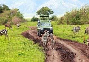
Figure 1. African Buffaloes in Dhati Welel National Park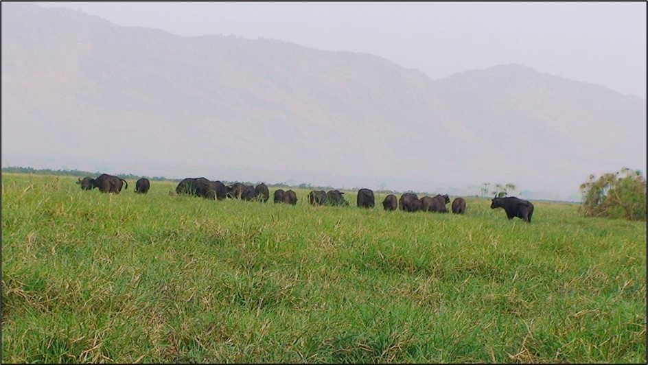
Download figure
The most common resources of the park are; the wetland biodiversity including; wetlands dependent and wetlands associated birds, the extraordinary richness of Mega-fauna such as the African Buffalo, and Hippopotamus (Hippopotamus amphibius), and ample fish fauna. Vegetation consists of various floral species including wetland-dependent and wetland-associated plants, and a vegetation type known Sudan-Guinea savanna biome. The study area classified into four habitat types: Wetland, woodland, riverine forest and Savanna grass land. The Park shares the northwestern portion of the southwestern tropical forest part of the country and receives over 1,350mm average annual rainfall. As indicated in Rabira (2019) the area is relatively hot with mean maximum and minimum temperature ranging between 290C and 270C and between 150C and 170C respectively.
Datasets and GIS mapping
The data used for the habitat suitability analysis includes satellite imagery of Landsat 8, Shuttle Radar Topography Mission (SRTM) with 20m resolution (elevation and slope), toposheet (rivers), and settlements. For data preparation, organization, data analysis, and output generation, hardware and software were used. Softwares used for data processing and preparation are ArcGIS 10.5, and ERDAS IMAGINE 2015. To analyze the habitat suitability of Buffaloes in Dhati Welel National Park, the Literature Review and Expert Opinion Habitat Suitability Model were applied. Besides the discussion with Dhati Welel National Park members, published and unpublished materials were reviewed for the convenience of the study. Generally, in the process of habitat suitability analysis for Buffaloes, five factors including LULC, elevation, slope, river, rainfall, and settlement were used.
The study employed LULC interpretation and classification of the study area as one factor. As a result, Landsat 8 OLI images of resolution 30m of the year 2019 were used by downloading from the United States Geological Survey websites. Then image geometric correction and stacking layer of each band were conducted subsequently by using ERDAS IMAGINE 2015 software. Following that, the mosaicking of two scenes was made in order to clip the images of the study area. Supervised classification was performed to classify the LULC of the Dhati Welel National Park. After that Accuracy assessment of the classified image was done by field observation and data was collected using handheld GPS apparatus from sample areas to match the classified image with ground features. Finally, the classified LULC image was crosschecked by overlaying it with Google Earth Image using ERDAS IMAGINE 2015 software. Settlement and river were digitized from the toposheets collected from the Ethiopian Mapping Agency and using ArcGIS 10.5 software proximity computation was performed and analyzed. The Elevation and Slope of the study area were generated from SRTM-30 meter resolution that was downloaded from the United States Geological Survey websites and analyzed using ArcGIS 10.5 software. Figure 2
Figure 2. Map of Dhati Welel National Park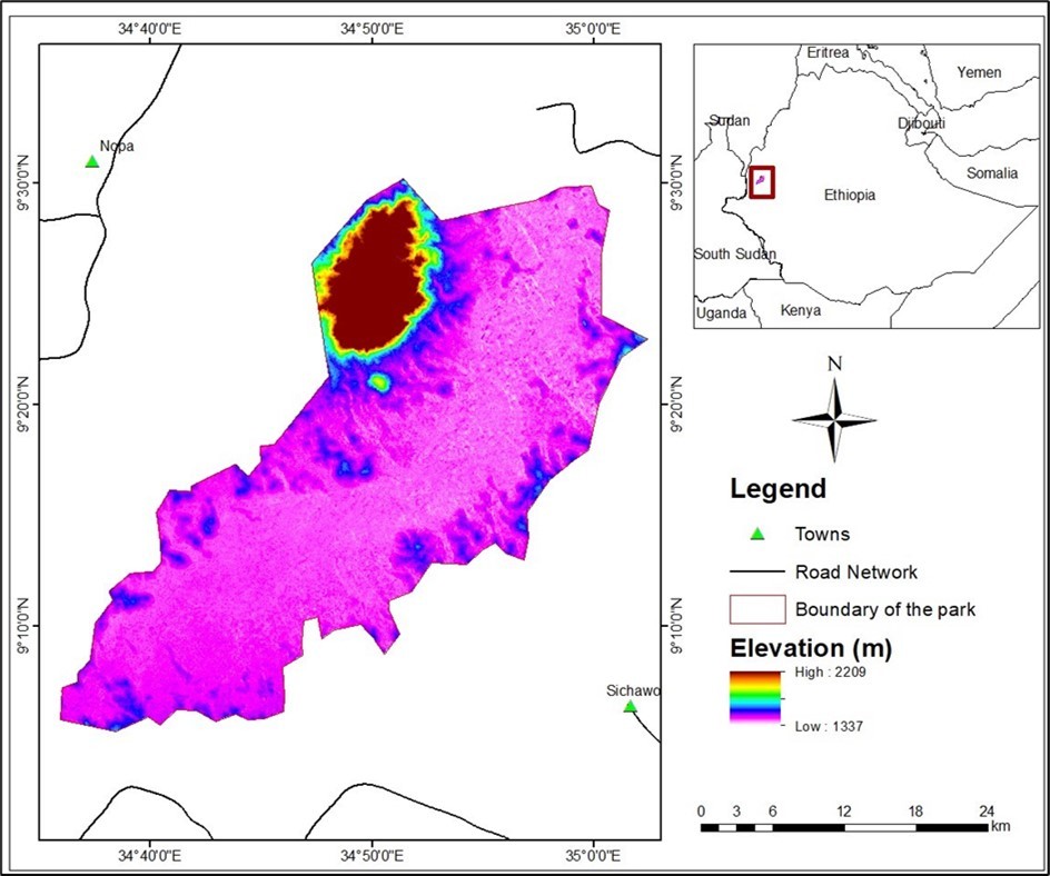
Download figure
After each variable converted from vector to raster (rasterization process) continuing through the performing of their analysis, reclassification was performed based on an attribute value that has been specified through ArcGIS software. A pairwise comparison method in the context of the Analytic Hierarchy process was used for the evaluation of the factors. Each assigned weight for the factors was based on a multi-criterion evaluation Analytical Hierarchy Process. The Analytic Hierarchy process uses a nine-point measurement scale i.e. 1 – Equal importance, 3 – Moderate importance, 5 – Strong importance, 7 – Very strong importance, and 9 – Extreme importance. The other values of 2, 4, 6, and 8 constitute intermediate values between two adjacent values.
The Weighted Overlay tool applies one of the most used approaches for overlay analysis to solve multicriteria problems such as suitability models. Each factor in the weighted overlay analysis may not be equal in importance. Weighted overlay analysis was computed using the Influence value assigned to each factor based on their significance in deciding habitat suitability for African Buffaloes.
Results and Discussion
All factors used in the study were geo-referenced, loaded into the Geodatabase, converted into raster format, and reclassified according to their suitability classes in the ArcGIS environment. After the reclassification process, the suitability classes were identified for each factor. The factor maps were reclassified based on suitability classification standards i.e. highly suitable, suitable, moderately suitable, and unsuitable. In this regard, highly suitable, suitable, and moderately suitable, are areas that in general called habitat-suitable ranges for African Buffaloes. Whereas unsuitable was an area that is not suitable for Buffaloes.
Based on literature reviews and information gathered through interviews on each factor, the following habitat suitability levels were identified for Buffaloes Table 1
Table 1. Weighted suitability analysis.| S/N | Factors | The level of suitability classes and RanksWhere 1. Unsuitable, 2: Moderately Suitable, 3: Suitable, and 4: Highly suitable | Influence (%) | Sources | |
|---|---|---|---|---|---|
| 1 | LULC (Type) | Agricultural lands=1 Shrub land=3 | Forests land= 2 Water bodies / Wetlands = 4 | 35.3 | (Parihar et al., 1986; Estes, 1991) |
| 2 | Slope (%) | >26.7=1 5.0-13.7 =3 | 13.7-26.7 =2 <5.0=4 | 12.3 | Pokhrel et al. (2019) |
| 3 | Proximity to Settlement (km) | <6=1 9-12=3 | 6-9=2 >12=4 | 7.3 | (Treves et al., 2006) |
| 4 | Proximity to River (m) | >700=12100-4400=3 | 4400-7000 =2<2100 =4 | 26.8 | (Parihar et al., 1986) |
| 5 | Elevation (m) | >1790=1 1420-1562 =3 | 1562-1790 =2 <1420 =4 | 18.4 | (Lamsal et al., 2016) |
LULC of the study area was one of the criteria used to select habitat sites for Buffaloes. The LULC was reclassified according to its suitability for Buffaloes habitats. Depending on the literature reviews and information gathered from the Park, the weight has been assigned for each LULC type. Wetlands are highly suitable and Water bodies are a life requirement for any species of wildlife including Buffaloes. Buffaloes live in swamps, floodplains, mopane grasslands, and the forests of the major mountains of Africa 17, 17, 9. It prefers a habitat with dense covers such as reeds and thickets 12, and also be found in open woodland. Buffaloes require water daily so they depend on perennial sources of water.
According to Lamsal (2016), the Suitable habitats of Buffaloes are extended to in lower elevations. They are found in dense lowland forests, lowland rainforests, montane forests and grasslands, Acacia grasslands, plains, and semi-arid bushland 22. The highest Buffaloes population densities are found in the wetland part of the Park which is a lower elevation of the study area. Figure 3
Figure 3. Factor suitability Maps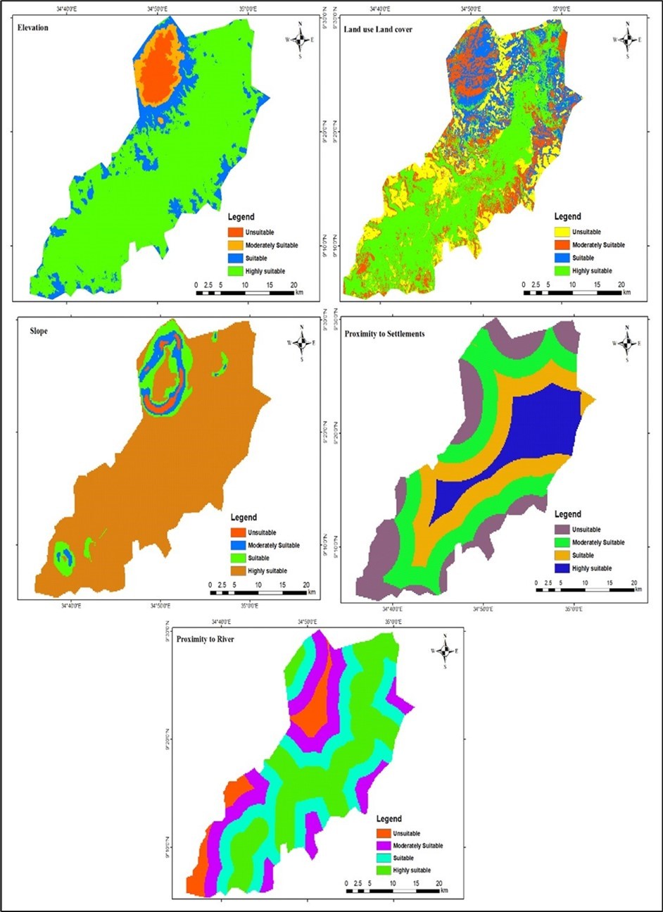
Download figure
According to Pokhrel et al. 27, the suitable habitat for Buffaloes on the slope point of view is along with flat or gently sloping areas. Therefore, Buffaloes prefer a gentle slope rather than a steep slope from the slope gradient perspective. As a result, Slope has been identified as an important factor for Buffaloes. Gentler slopes are more preferable and energy savers during grazing rather than the steepest slope.
Water is one of the life-supporting systems that allows all living things to survive on the surface of the earth (Sinha and Kaushik, 2010). It’s a crucial life requirement for every species and the suitable habitat for Buffaloes is near the rivers. Buffaloes show a preference for riverine habitats, especially in the dry season. They prefer close proximity of less than 1 km to water and are only found within 20 km of water 35. Therefore, suitable habitat for the Buffaloes species is recommended if water is available within a 20km radius. As result, the area found within a 1km distance to the river is termed as a suitable region for Buffalo’s habitat.
Human interference is one of the most problems that disturb the conditions of wildlife including Buffaloes 10, 34. In and around Dhati Welel National Park, settlements are increased in all areas of the park including the remote and inhospitable areas. As a result, the habitats are more profoundly modified by the human population. Buffaloes are not suitable for living with the closest human settlements. A Settlement with agriculture overwhelmed a large area of woodlands around the wetlands of the park which was the part of former ranges for Buffalo, and therefore, forced Buffaloes to a swampy plain.
The reclassified layers were combined in order to select suitable habitat sites for Buffaloes in the study area. All factors cannot have equal preferences as a result; weighting was used to express the importance or preference of each factor relative to another factor. Accordingly, five factors were standardized and computed by using IDRISI 17 software to produce their weights.
Consequently, the weighted overlay tool in the ArcGIS spatial analyst extension was used to combine all factors according to their rank and weight that has been computed from the pairwise comparison matrix to select the intended outcomes for the suitable habitat of Buffaloes in the study area. Table 2
Table 2. Weights of the factors using pairwise comparison matrices| Factors | LULC. | River | Elevation | Slope | Settlement | Weight | Weight (%) |
| LULC. | 1 | 0.35 | 35.3 | ||||
| River | 1/2 | 1 | 0.27 | 26.8 | |||
| Elevation | 1/3 | 1/2 | 1 | 0.18 | 18.4 | ||
| Slope | 1/3 | 1/3 | ½ | 1 | 0.12 | 12.3 | |
| Settlement | 1/5 | 1/5 | 1/3 | 1/3 | 1 | 0.07 | 7.3 |
| Totals | 1.00 | 100 |
As it is shown on the above map (Figure 4), the area indicated by dark blue and light blue colors are suitable and highly suitable for the habitats of Buffaloes. These areas are found around the central and wetland-dominated portion of the National Park. The remaining area shown on the map in red and black color represents the area moderately suitable and unsuitable for Buffaloes habitat respectively. From the total area of the park, 35.4% (362.7km2), and 44.1% (452.8km2) found as highly suitable and suitable for Buffaloes habitats respectively. These areas fulfill the optimal requirement for habitats based on the factors analyzed in the study. The remaining 20.4% (209.3km2), and 0.1% (1.1km2) of the study area were found as moderately suitable and unsuitable for the habitat of Buffaloes respectively. These were areas occupied by anthropogenic activities and known by habitat fragmentation in the park.
Figure 4. Buffaloes habitat Suitability Map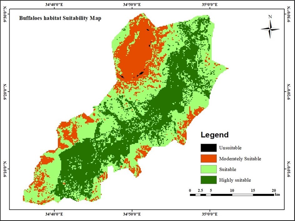
Download figure
Conclusion
Dhati Welel National Park is one of the protected areas in western Ethiopia with large areas of wetland habitats and it supports several species like African buffalo. The intention of this study was to analyze habitat suitability for African Buffaloes by employing GIS at Dhati Welel National Park. In this study, five environmental factors were used to generate a suitable habitat map of the study area including elevation, slope, LULC, rivers, and settlements. A GIS-based method was employed to identify suitable habitat sites. The findings of this study have shown that the central parts of the Park were found more suitable for African Buffaloes due to the existence of important environmental factors that are the necessary conditions for their living. The peripheries of the Park were found to be unsuitable for Buffaloes habitat due to the presence of settlements, which pose anthropogenic pressure. Generally, the findings of this study have shown that 35.4% (362.7 km2) area of the park is the optimal habitat zone for African Buffaloes. The habitat suitability maps produced in the study can be used as a tool for wildlife conservation and management programs.
Disclosure statement
There is no conflict of interest regarding this study.
References
- 1.A O, Banerjee A, M K Jhariya, L N Muoghalu, A U Okonkwo et al. (2023) Climate-induced conflicts between rural farmers and cattle herders: Implications on sustainable agriculture and food security in Nigeria. https://doi.org/10.1002/9781119879954.ch12
- 2.Banerjee A, M K Jhariya, S, Palit D. (2023) . Ecorestoration for Sustainability.https://onlinelibrary.wiley.com/doi/book/10.1002/9781119879954
- 3.T G Benton, J A Vickery, J D Wilson. (2003) Farmland biodiversity: is habitat heterogeneity the key? Trends in Ecology and Evolution.
- 4.V K Bhagat, D K Yadav, M K Jhariya.A Comprehensive Study on Ecological Aspect, Feeding Behaviour and Pugmark Analysis of Elephants in the Bordering Areas of Northern Chhattisgarh. , Journal of Human Ecology 58(1), 41-47.
- 5.V K Bhagat, D K Yadav, M K Jhariya.Human-Elephant Conflict and its Consequences: A Preliminary Appraisal and Way Forward. , Bulletin of Environment, Pharmacology and Life Sciences 6(7), 85-94.
- 6.Thomas M Brooks, Russell A Mittermeier, Cristina G Mittermeier, Fonseca Gustavo AB Da, Anthony B Rylands et al. (2002) Habitat loss and extinction in the hotspots of biodiversity. , Conservation 16, 909-923.
- 7.Cerling T, Harris J, Passey B. (2003) Diets of East African Bovidae based on stable isotope analysis. , Journal of Mammalogy 84, 456-470.
- 8.R D Clark, Mathieu R, P J Seddon. (2008) Geographic Information Systems in wildlife management: a case study using Yellow-eyed penguin nest site data. Department of Conservation.
- 9.Codron D, Codron J, Lee-Throp J, Sponheimer M, D de Ruiter et al. (2007) Diets of savanna ungulates fromstable carbon isotope composition of faeces. , Journal of Zoology 273, 21-29.
- 10.M R Conover. (2001) Resolving human-wildlife conflicts: the science of wildlife damage management.
- 11.Dirzo R, P H Raven. (2003) Global state of biodiversity and loss. Annual review of Environment and Resources. 28(1), 137-167.
- 12.Estes R. (1991) The Behavior Guide to African Mammals, Including Hoofed Mammals, Carnivores, Primates. Los Angeles, The University of California Press. 195-200.
- 13.P H Evangelista, Norman J, Swartzinki P. (2012) Assessing habitat quality of the mountain nyala Tragelaphus buxtoni in the Bale Mountains. , Ethiopia, Current Zoology 58(4), 525-535.
- 14.R M Ewers, R K Didham. (2006) Confounding factors in the detection of species responses to habitat fragmentation. , Biological reviews 81(1), 117-142.
- 15.G J, Mathieu R, P J Seddon. (2006) Predictive modelling and ground validation of the spatial distribution of the New Zealand long-tailed bat (Chalinolobus tuberculatus). , Biological Conservation 132(2), 211-221.
- 16.Hauer A, K De Cruz, Cochard T, Godreuil S, Karoui C et al. (2015) Genetic evolution of Mycobacterium bovis causing tuberculosis in livestock and wildlife in France since. , PloS one 10(2), 0117103.
- 17.Hughes Kristen, Geoffrey T Fosgate, Christine M Budke, Michael P Ward, Kerry Ruth et al. (2017) Modeling the spatial distribution of African buffalo. (Syncerus caffer) in the Kruger National Park, South Africa". PLOS ONE. 12 (9): e0182903. Bibcode: 2017PLoSO..1282903H. doi: 10.1371/journal.pone.0182903. PMC 5597095. PMID , Ben 28902858.
- 18.Imam E, G Y Tesfamichael. (2013) Use of remote sensing, GIS and analytical hierarchy process (AHP) in wildlife habitat suitability analysis. , Journal of Materials and Environmental Science 4(3), 460-467.
- 19.Ketema T, Lemi G, Liban J. (2022) GIS and Remote Sensing Based Spatiotemporal Analysis of Deforestation in Dati Wolel National Park. , Western Ethiopia, American Journal of Agriculture and Forestry 10(1), 1-8.
- 20.S M Lenton, J E Fa, Val Del, P J. (2000) A simple non-parametric GIS model for predicting species distribution: endemic birds in Bioko Island. , West Africa. Biodiversity & Conservation 9(7), 869-885.
- 21.Mamo Y, Bekele A. (2011) Human and livestock encroachments into the habitat of Mountain Nyala (Tragelaphus buxtoni) in the Bale Mountains National Park. , Ethiopia. Tropical Ecology 52(3), 265-273.
- 23.Myers N, R A Mittermeier, C G Mittermeier, Fonseca Da, A G et al. (2000) Biodiversity hotspots for conservation priorities. , Nature 403(6772), 853-858.
- 24.Nelson A. (2011) General Management Planning for the Bale Mountains National Park. , Walia 243, 243-256.
- 25.J S Parihar, P C Kotwal, Panigrahi S, Chaturvedi N. (1986) Study of Wildlife Habitat Using High Resolution Space Photographs: A Case. , Study of Kanha National Park. ISRO-SP-17-86, Special Publication of Indian Space Research Organization, Space ApplicationsCentre, Ahmedabad 65, pp..
- 26.J S Parihar, P C Kotwal, Panigrahi S, Chaturvedi N. (1986) Study of Wildlife Habitat Using High Resolution Space Photographs: A Case. , Study of Kanha National Park. ISRO-SP-17-86, Special Publication of Indian Space Research Organization, Space ApplicationsCentre, Ahmedabad 65, pp..
- 27.Pokhrel K, Poudel P, Neupane B, Paudel R. (2019) Comparative study in habitat suitability analysis of wild water buffalo (Bubalus arnee) in two flood plains of Chitwan National Park (CNP). , Nepal. International Journal of Research Studies in Zoology 5(3), 1-10.
- 28.Rabira G. (2019) Threats, Community Perception of Biological Resource Conservation and Solution. in Dhati Welel National Park of Ethiopia. International Journal of Scientific Research in Biological Sciences. Vol.6, Issue.6 120-128.
- 29.J E Sanare, E S Ganawa, Abdelrahim A M S. (2015) Wildlife Habitat Suitability Analysis at Serengeti National Park (SNP), Tanzania Case Study Loxodonta sp. J Ecosys Ecograph ISSN: 2157-7625 JEE, an open access journal Volume 5• Issue , J Ecosys Ecograph 5, 164-10.
- 30.Sih A, B G Jonsson, Luikart G. (2000) Habitat loss: ecological, evolutionary and genetic consequences. , Trends in Ecology & Evolution 15(4), 132-134.
- 31.A K Thakur, D K Yadav, M K Jhariya. (2015) Human-Elephant Conflict Scenario in Corridors of Northern Chhattisgarh. , Journal of Plant Development 7(11), 821-825.
- 32.A K Thakur, D K Yadav, M K Jhariya. (2016) Feeding Behaviour and Pugmark Analysis of Elephants in Sarguja. , Chhattisgarh. Journal of Applied and Natural Science 8(4), 2060-2065.
- 33.A K Thakur, D K Yadav, M K Jhariya. (2016) Socio-economic status of Human Elephant Conflicts its Assessment and Solutions. , Journal of Applied and Natural Science 8(4), 2104-2110.